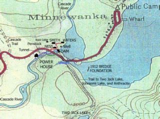
It's not easy to find information on what Lake Minnewanka was like before the dams were built. Information is sketchy and there are very few pictures. My biggest questions were what was the shoreline and what path did the Cascade river take? And, did Two Jack lake flow into that basin then down the Cascade river? So I got a topographic chart and drew out an estimate based on depth. The earliest map I've found with the shoreline has the lake at the current 72 foot level, which would have been the shoreline after the 1912 dam was built. If I find a photo before that, I'll be sure to post it!
